
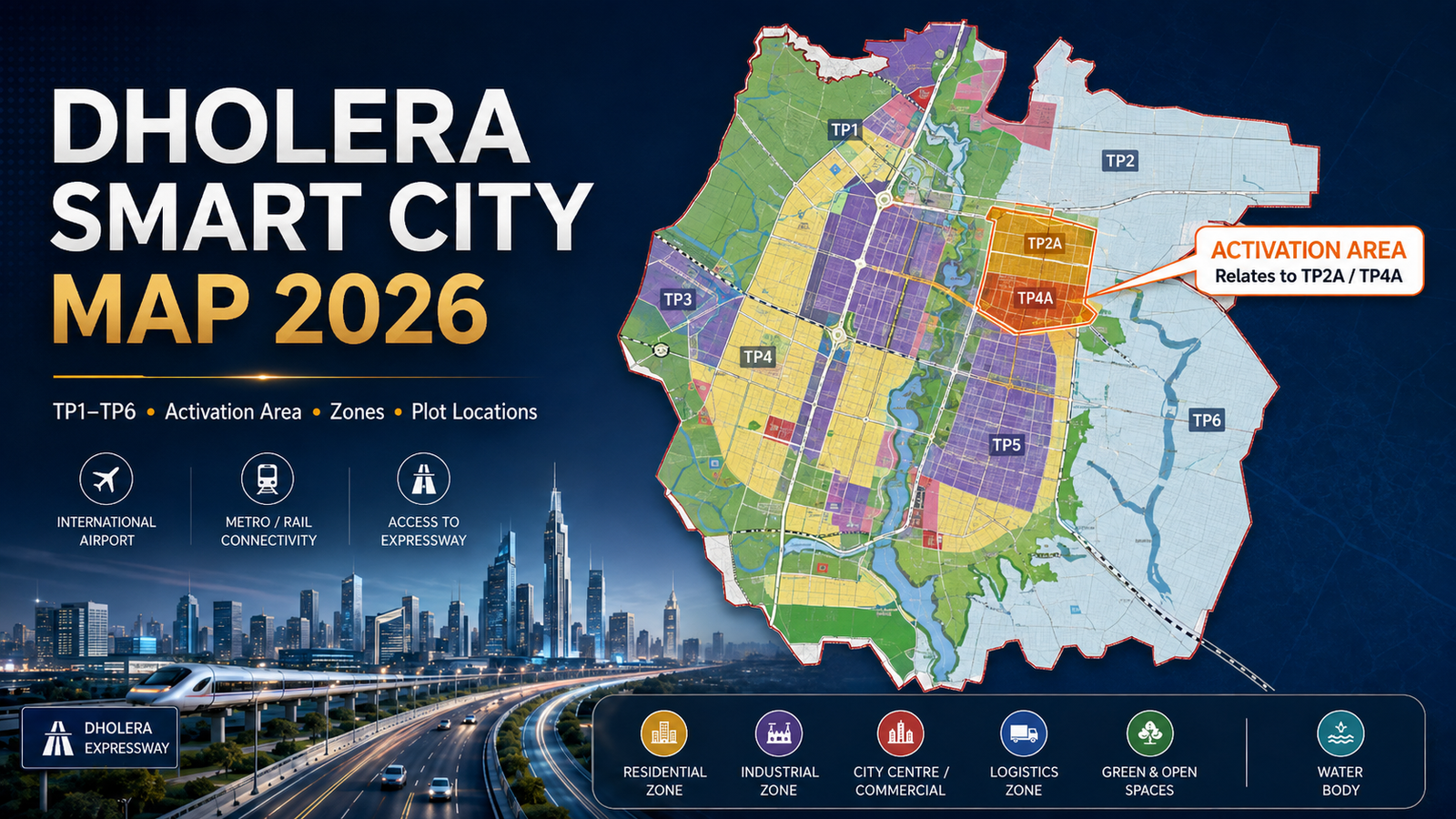
Dholera Smart City Map 2026: TP1–TP6, Activation Area, Zones & Plot Locations Explained
Dholera Smart City is one of India’s most ambitious planned industrial and urban development projects. For property buyers and investors, understanding the Dholera Smart City Map 2026 is essential before purchasing land or plots.
Dholera Special Investment Region, also known as Dholera SIR, covers approximately 920 sq. km. However, the entire region is not planned as one type of development. It includes residential areas, industrial zones, logistics hubs, commercial areas, green spaces, infrastructure corridors and several Town Planning Schemes.
This guide explains TP1 to TP6, the Activation Area, important land-use zones and what buyers should check before investing in Dholera.
Understanding the Dholera Smart City Map
The Dholera Smart City map is based on a detailed Development Plan. It divides the region according to future land use and infrastructure requirements.
Major planning categories include:
- Residential zones
- Industrial zones
- City Centre
- High Access Corridor
- Knowledge and IT zones
- Logistics areas
- Tourism and resort zones
- Recreation and sports areas
- Public facilities
- Green spaces
- Existing village settlements
- Solar energy areas
- Roads and utility infrastructure
For buyers, this means two plots within the broader Dholera region can have very different future potential depending on their exact location, zoning and connectivity.
Dholera TP1 to TP6 Explained
Dholera SIR includes six major Town Planning Schemes. Together, TP1 to TP6 cover approximately 422.42 sq. km.
| Town Planning Scheme | Approx. Area | Buyer Consideration |
| TP1 | 51.40 sq. km | Part of Phase I; check exact land use and infrastructure status |
| TP2 | 102.34 sq. km | Part of Phase I and connected with early development areas |
| TP3 | 66.60 sq. km | Part of the wider future development framework |
| TP4 | 60.00 sq. km | Includes planned urban development areas |
| TP5 | 74.75 sq. km | Part of the long-term expansion of Dholera |
| TP6 | 67.33 sq. km | Forms part of the wider planned development region |
Phase I of Dholera includes TP1 and TP2, covering approximately 153 sq. km.
However, buyers should not assume that every plot within TP1 or TP2 already has completed infrastructure. A Town Planning Scheme defines planning and development structure, but actual on-ground development can vary by location.
Before purchasing, buyers should verify the survey number, land-use category, road access, ownership documents and development status.
What Is the Dholera Activation Area?
The Dholera Activation Area is one of the most important parts of the project.
It covers approximately 22.54 sq. km and represents the initial area where major trunk infrastructure has been developed.
The Activation Area is associated with approved TP Scheme 2A and TP Scheme 4A. It should not be confused with the entire TP2 or TP4 areas.
Major infrastructure in and around the Activation Area includes:
- Internal road networks
- Water supply
- Wastewater management
- Storm-water drainage
- Power distribution
- ICT infrastructure
- Utility corridors
- Public infrastructure
The Activation Area is significant because it shows where Dholera's smart-city development has moved most visibly from planning to execution.
Major Zones in the Dholera Smart City Master Plan
Residential Zones
Residential areas are planned to support the future population working across Dholera's industrial, technology and commercial ecosystem.
Buyers considering residential plots should check not only whether a plot is "in Dholera", but also whether its official land-use designation is residential.
Industrial Zones
Industrial development is one of Dholera's core economic drivers.
The region is being positioned for industries such as semiconductors, aerospace and defence, solar manufacturing, engineering, pharmaceuticals and other advanced manufacturing sectors.
Industrial growth can also support future demand for housing, retail and services.
High Access Corridor
The High Access Corridor is planned around major connectivity routes and supports higher-access urban and commercial development.
However, buyers should verify whether a property actually falls within this designated corridor rather than relying only on marketing claims.
City Centre
The City Centre is planned as an important commercial and urban activity zone.
As Dholera develops, such areas are expected to support offices, services, retail and other business activity.
Knowledge and IT Zone
Dholera's planning also includes space for technology, education, research and knowledge-based industries, supporting development beyond traditional manufacturing.
Logistics and Transport Zones
Dholera is being planned as a major industrial and logistics hub. Its logistics zones are supported by large infrastructure projects connecting Dholera with Ahmedabad and other economic centres.
Why the Dholera Map Matters More in 2026
Several major connectivity projects have progressed significantly by 2026.
Ahmedabad-Dholera Expressway
The Ahmedabad-Dholera Expressway was inaugurated on March 31, 2026.
The access-controlled expressway has significantly improved connectivity between Ahmedabad and the Dholera region. For property buyers, this makes actual road connectivity to project locations increasingly important.
Dholera International Airport
As of the latest official updates in 2026, Dholera International Airport remains under development.
The airport is expected to strengthen future passenger, cargo and industrial connectivity once operational.
Ahmedabad-Dholera Semi-High-Speed Rail
In May 2026, the Union Cabinet approved the approximately 134-km Ahmedabad-Dholera Semi-High-Speed Double Line railway project.
The proposed rail connection is expected to link Ahmedabad, Dholera SIR, Dholera Airport and Lothal, further strengthening the region's long-term connectivity.
How to Check a Dholera Plot Location Before Buying
Before investing, buyers should use the Dholera map together with proper legal and on-ground verification.
Check the following:
- Exact survey or block number
- Applicable Town Planning Scheme
- Official land-use zone
- Road connectivity
- Original Plot and Final Plot details, where applicable
- Ownership and title documents
- Nearby infrastructure
- Actual distance from major projects
- Current development status
- Physical site condition
A Google Maps location or marketing brochure should never replace official land records and proper legal verification.
How Garg Realty Group Helps Dholera Buyers
Garg Realty Group has been operating in the real estate sector since 2007 and works with property buyers looking for opportunities in Dholera and other emerging markets.
Its Dholera portfolio includes projects such as Orchid Garden and Sukkoon City.
For buyers exploring plots in Dholera, Garg Realty Group can help with:
- Project location understanding
- Available plot options
- Site visits
- Infrastructure overview
- Location comparison
- Property documentation guidance
- Long-term investment evaluation
The objective is to help buyers understand where a project is located and how it fits into Dholera's larger planning framework.
Conclusion
The Dholera Smart City Map 2026 is one of the most useful tools for understanding how the region is being developed.
Dholera SIR covers approximately 920 sq. km, while TP1 to TP6 together cover about 422.42 sq. km. Within this larger framework, the 22.54 sq. km Activation Area represents one of the most advanced early-development zones.
For buyers, the best approach is not to judge a plot only by its distance from the airport or expressway.
Instead, evaluate:
Location + TP Scheme + Land Use + Connectivity + Documentation
A clear understanding of these factors can help buyers make more informed decisions when considering property in Dholera.
Frequently Asked Questions
1. What is the total area of Dholera Smart City?
Dholera Special Investment Region covers approximately 920 sq. km, making it one of India's largest planned greenfield industrial cities.
2. How many Town Planning Schemes are there in Dholera?
Dholera includes six major Town Planning Schemes — TP1, TP2, TP3, TP4, TP5 and TP6. Together they cover approximately 422.42 sq. km.
3. What is the Dholera Activation Area?
The Activation Area is approximately 22.54 sq. km and represents the initial development zone where major trunk infrastructure has been created.
4. Is Dholera International Airport operational in 2026?
As of the latest official updates in 2026, Dholera International Airport is still under development and has not yet become fully operational.
5. What should I check before buying a plot in Dholera?
Buyers should verify the survey number, TP scheme, land-use category, ownership documents, road access, nearby infrastructure and actual on-ground location before making a purchase.